Connecting a PPP Base Station to DJI M350 RTK: Step-by-Step
Field guide: feed RTCM corrections from a self-converging base to a DJI Matrice 350 RTK — no CORS, no internet.
What you need before the first flight
The shopping list is short: a DJI Matrice 350 RTK (the workflow is identical for the Matrice 300 RTK, Matrice 4E/4T, and Mavic 3 Enterprise), the DJI RC Plus running DJI Pilot 2, and a correction source. DJI's own options are the D-RTK 2 Mobile Station and the newer D-RTK 3 Multifunctional Station, or a network RTK subscription consumed as Custom Network RTK. This guide uses a third path that is gaining ground fast: a self-converging PPP base station that computes its own centimetre coordinates and serves standard NTRIP — no known point, no CORS account, no internet required.
Why not just average a base position? Because absolute accuracy matters the moment you overlay flights, import into machine-control models, or return next quarter. DJI's specifications put an uncalibrated D-RTK 3 single-point position at roughly 1.5 m horizontal / 3.0 m vertical; its satellite-based differential mode reaches 30 cm / 40 cm after about 20 minutes; centimetre absolute coordinates require calibrating against network RTK or a known point. A PPP base skips that dependency by converging to about 1.5 cm in ITRF2020 on its own, in roughly 3 minutes (see how self-converging bases work).
Step 1 — Place the base and let it converge
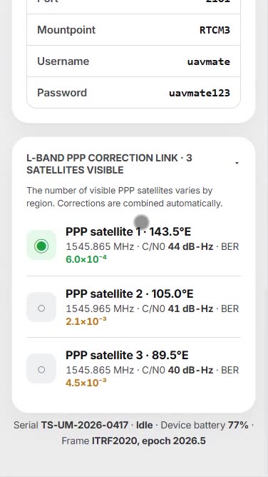
Screw on the UHF whip antenna, set the base on open ground with clear sky, and press power. No tripod, no tribrach, no averaging timer. Join the base's Wi-Fi hotspot from your phone and open the device console at 192.168.2.1:8080. You will see the PPP engine acquire L-Band correction satellites and converge: the status card counts down from metres to centimetres, typically reaching survey grade in about three minutes under open sky. Use that time to unfold the M350's arms and load batteries — the base will be ready before the aircraft is.
Step 2 — Start base mode and read off the NTRIP details
When the console shows Converged, tap Start base station. The base locks its PPP coordinates as the reference and begins broadcasting RTCM 3.x. The console now displays everything DJI Pilot 2 will ask for: NTRIP host, port, mountpoint, username, and password for the 4G path — or confirms the UHF radio and RC-link paths are live for internet-free sites. Enable raw RINEX logging on the same screen if you want a PPK backup; at 1 Hz it costs nothing and has rescued countless missions.
Step 3 — Point the Matrice at the corrections in DJI Pilot 2
On the RC Plus: enter the camera view, tap the three dots (⋯) for system settings, choose RTK. Set RTK Service Type to Custom Network RTK, then enter the host, port, mountpoint, and credentials exactly as the base console shows them. Tap Save — Pilot 2 connects, and within seconds the RTK status panel should report a FIX solution with the positioning standard deviations collapsing to centimetres. From here every photo the P1 or L2 payload captures carries centimetre geotags, and functions like terrain follow and precision route repeat run on the corrected position.
If the controller has no internet route to the base (no SIM, no shared hotspot), use the offline paths instead: the base's UHF radio to a receiving radio, or — simplest for drone-only jobs — corrections over the aircraft's own RC link where supported. The RTCM content is identical on every path; only the transport changes (full comparison in Radio vs NTRIP vs RC link).
Verifying FIX before you commit the mission
Thirty seconds of discipline here saves reflights. Confirm three things on the RTK panel: status reads FIX (not FLOAT — decimetre accuracy that looks deceptively healthy); the correction age sits at 1–2 s; and the reported standard deviations are in the 1–2 cm band. DJI's support literature is blunt that most “RTK was on but accuracy is bad” cases were flown in FLOAT. If FIX will not settle, our troubleshooting checklist walks the usual suspects: sky view, credentials, correction age, and multipath.
After the flight: processing and repeatability
Geotagged images drop straight into Pix4D, Agisoft Metashape, or DJI Terra with centimetre camera positions; most teams keep two or three independent checkpoints — not full GCP grids — to prove accuracy (the arithmetic is in Do you still need GCPs?). Because the base positioned itself absolutely in ITRF2020, next month's flight lands on top of this one without re-registration: same base spot or not, the frame is the same. That single property — repeatable absolute coordinates with zero control work — is what the PPP base buys a Matrice program.
Choosing a correction source: the honest comparison
| Source | Absolute accuracy of base | Needs internet / CORS | Setup time | Notes |
|---|---|---|---|---|
| D-RTK 2 Mobile Station | Averaged or known point; metre-class uncalibrated | For calibration | Minutes + calibration | OcuSync/4G/Wi-Fi/LAN transports; IP65 |
| D-RTK 3 Multifunctional Station | 1.5 m single point; 30 cm after ~20 min satellite differential; 1 cm with network RTK calibration | For centimetre absolute | Minutes to ~20 min | Broadcast / Relay / Rover modes; OcuSync 4 |
| Network RTK (VRS Now, SmartNet, state CORS) | Centimetre where covered | Yes, continuously | Credentials only | Per-rover annual subscription; 30–40 km baseline limit |
| Self-converging PPP base (UAV Mate) | ~1.5 cm H / 3 cm V in ~3 min, ITRF2020 | No | ~5 min total | RTCM 3.x over UHF, 4G NTRIP, or RC link; unlimited rovers |
None of these are bad tools. The question is which dependency you can live with: DJI's stations tie centimetre absolute accuracy to an external calibration; network RTK ties every mission to coverage and a subscription; the PPP base ties you only to open sky. For crews that fly beyond the network — or simply refuse to babysit credentials — the last column wins on operational grounds.
Gotchas that cost pilots an afternoon
Four recurring ones. First, entering the mountpoint with the wrong case — NTRIP mountpoints are case-sensitive, and Pilot 2 will connect to the caster yet receive nothing. Second, confusing the controller's internet with the aircraft's: Custom Network RTK runs through the RC Plus, so the controller needs the data path (its SIM, Wi-Fi to the base, or a phone hotspot). Third, flying immediately after FIX: give the solution ten seconds of stable standard deviations before takeoff, especially near vehicles or containers that throw multipath. Fourth, forgetting that RTK availability does not equal RTK accuracy — a mission flown in FLOAT still writes geotags, just decimetre ones. The RTK panel, not the photo count, is the truth.
Frequently asked questions
Does this work with the Matrice 4 and Mavic 3 Enterprise too?
Yes. Any DJI Enterprise aircraft that accepts Custom Network RTK in DJI Pilot 2 — Matrice 350/300 RTK, Matrice 4E/4T, Mavic 3E/3T, Phantom 4 RTK — consumes the base's RTCM 3.x stream identically.
Can the base serve several drones at once?
Yes. RTCM over NTRIP or radio is a broadcast; multiple aircraft and ground rovers can consume the same stream simultaneously with no pairing.
Do I need internet at the site?
No. The base gets PPP corrections from L-Band satellites, and the drone can take RTCM over the UHF radio or RC link. Internet (4G NTRIP) is just the most convenient transport when it exists.
How is this different from a D-RTK 2 or D-RTK 3?
DJI's stations are excellent transports but need external calibration (network RTK or a known point) for centimetre absolute coordinates. A self-converging PPP base computes its own 1.5 cm ITRF2020 position in minutes, with no network dependency.
Centimetre RTK. No CORS. Anywhere.
UAV Mate is a self-converging PPP/RTK base station: 1.5 cm ITRF2020 coordinates in minutes, broadcast to any RTCM 3.x drone or rover.
See UAV Mate